How Pacific wayfinding, archaeoastronomy, GPS, satellite observation, and maps beyond Earth reveal changing relationships between knowledge, technology, and the ways unfamiliar environments are understood.
Humans were learning to read the sky thousands of years before anything resembling a modern map existed. Celestial knowledge could be carried through oral traditions, navigation, architecture, calendars, stories, diagrams, written records, and systems of memory. What survives materially represents only part of that history because not every culture recorded knowledge in a form designed to last for centuries, and not every system of understanding the sky required a drawn map at all.

Surviving Babylonian astronomical texts such as MUL.APIN organized stars, constellations, the path of the Moon, and the seasonal rising and setting of celestial bodies. In China, generations of astronomical observation eventually produced works such as the Dunhuang Star Atlas, created around the seventh century CE, approximately 1,300 years ago, and now considered the oldest known complete surviving star atlas. Its thirteen charts contain more than 1,300 stars visible to the naked eye from north-central China. Across Oceania, celestial knowledge developed within navigational traditions in which stars were understood through their movements and relationships to the horizon, winds, swells, islands, and routes across the ocean.
These were not incomplete attempts to create the kinds of maps we use now. They organized knowledge according to different environments, technologies, cultural traditions, and reasons for observing the sky. Archaeoastronomy helps reconstruct some of these relationships by examining how past cultures observed, interpreted, and incorporated celestial knowledge into everyday life.
Over time, the ways people observed and interpreted the sky changed with the tools available to them. Naked-eye observation gave way to instruments that could measure angles and time more precisely, while telescopes revealed details that could not be seen unaided. Later technologies, including photography, radar, spectroscopy, spacecraft imaging, thermal sensing, and orbital surveys, made it possible to study characteristics of other worlds that human vision alone could not capture.
The tools changed not only what people could learn, but how they learned it. A navigator reading stars and swells, an astronomer observing through a telescope, and a scientist studying data from an orbiting spacecraft are all interpreting environments through different forms of observation.
Credit: British Museum
Modern technology has extended human perception far beyond the limits of direct experience. We can map the far side of the Moon without standing there, identify minerals from orbit, monitor environmental changes across continents, calculate trajectories through cislunar space, and reconstruct worlds millions or billions of kilometers away. More of that knowledge now reaches us through instruments, measurements, software, mathematical models, images, and automated analysis rather than sustained direct observation.
The relationship between observer, tool, and environment is therefore as interesting as the map itself. Technology allows us to know far more about places we cannot directly experience, while sometimes reducing how much of an environment we personally have to observe, remember, or understand in order to move through it. Navigation history makes that tension especially visible because different cultures have developed very different answers to a basic question: what do you need to know about an environment to find your way through it?
Different Ways of Knowing Where You Are
By the eighteenth century, European maritime navigation combined charts, instruments, astronomical observations, and mathematical calculation. Mariners could use a compass to maintain direction and estimate movement from course, speed, and elapsed time. A sextant allowed a navigator to measure the angle between a celestial body and the horizon. Astronomical tables could help determine latitude and contribute to longitude calculations, while more accurate marine chronometers allowed navigators to compare local time with the time at a known reference point.
The navigator was still reading the sky and ocean, but those observations were translated into measurements. A star could become an angle. Time could help determine longitude. Movement could be recorded as distance and heading. Latitude and longitude created a standardized geographic framework in which a ship’s position could be represented numerically and transferred onto a chart.
Across Oceania, navigators had developed other systems for crossing some of the largest stretches of open ocean on Earth. These traditions were not interchangeable. Polynesian, Carolinian, Marshallese, and other Micronesian cultures developed navigational practices within different environmental, linguistic, and cultural contexts. Some shared forms of celestial and environmental observation, but they did not necessarily organize or transmit that knowledge in the same way.
In Polynesian wayfinding traditions, the rising and setting positions of celestial bodies could provide direction while winds, currents, ocean swells, clouds, birds, and other signs contributed additional information. The navigator also had to remember how the canoe had moved. Direction, speed, time, changes in course, and the relationship between the vessel and its destination became part of an internal model that had to be continually maintained.


Mau Piailug using a star compass to teach navigation to his son on Satawal, 1983. Credit: Steve Thomas
Hawaiian Star Compass, also known as the Kūkuluokalani. Credit: Nainoa Thompson
The Hawaiian star compass developed by Nainoa Thompson during the modern revival of non-instrument wayfinding makes this approach easier to understand. Thompson learned from Mau Piailug, a master navigator from Satawal in Micronesia, while also studying astronomy, meteorology, and oceanography. His Hawaiian star compass organizes the horizon into thirty-two named houses associated with the rising and setting positions of celestial bodies. Waves, winds, and bird movements can also be interpreted through the same directional framework. It is not an instrument held in the navigator’s hand but a mental system used to organize what is being observed around the canoe. Using it requires attention and memory. The navigator has to track changes in heading, time, stars, swells, and other environmental information because there is no device continuously calculating and displaying an updated position.
European maritime navigation and Pacific wayfinding could therefore solve similar problems while organizing knowledge differently. One converted environmental observations into measurements that could be recorded and reproduced on standardized charts. The other would require the navigator to carry much of the environmental model internally, continually updating relationships among the traveler, the ocean, the sky, time, memory, and destination. Tupaia’s Map shows what happened when those approaches were brought onto the same piece of paper.
The Map That Looked Wrong
Tupaia was an arioi priest, chiefly advisor, and master navigator from Ra‘iātea in Eastern Polynesia. When he joined James Cook’s Endeavour in 1769, he carried extensive knowledge of islands and voyaging routes across Oceania. During the voyage, he collaborated with members of Cook’s crew to place some of that knowledge onto a chart that eventually became known as Tupaia’s Map.
However, none of the original charts created with Tupaia aboard the Endeavour survived. What exists today are later copies made from different stages of that work. German naturalist and explorer Georg Forster produced a copy of an earlier draft in 1776, while another copy commissioned by Joseph Banks preserved a later version. Researchers have reconstructed the development of Tupaia’s cartographic system from those copies alongside journals, island lists, and other records. What we now refer to as “Tupaia’s Map” is therefore not a surviving original but a reconstruction based on documents that had already passed through copying, transcription, and interpretation.

Tupaia’s chart of the Pacific, created around 1769, recording islands and spatial relationships through a Polynesian navigational knowledge system. Credit: British Library
For generations, many of the mapped islands appeared to European readers to be in the wrong places because the chart was being interpreted according to familiar European cartographic expectations. Islands separated by enormous distances could appear unusually close together, while others occupied positions that made little sense when the page was treated as a conventional fixed map. Georg Forster himself questioned Tupaia’s geographical knowledge, and later researchers continued trying to reconcile the chart with European mapping conventions.
In a 2019 study of Tupaia’s map, researchers Lars Eckstein and Anja Schwarz argued that the chart was built around a different navigational logic than the European maps it was later compared against. Their reconstruction suggests that Tupaia used avatea, associated with noon and the Sun at its highest point, as a directional reference. Rather than treating north as a fixed position at the top of the page, the chart could be read from the perspective of a traveler located at one island and orienting toward another along a known voyaging route. Other Pacific scholars have challenged parts of this interpretation, but the disagreement itself shows how difficult it can be to interpret a map when its underlying system does not match the conventions a reader expects.
Within Eckstein and Schwarz’s reconstruction, the overall position of every island on the sheet was not meant to function like its position on a conventional European map using a fixed projection. Relationships along particular voyaging routes carried much of the information. When they reconstructed those routes according to this cartographic logic, many bearings that had appeared inaccurate closely matched bearings calculated with modern mapping methods.
European readers therefore had a representation of Pacific geographical knowledge in front of them, yet for generations misunderstood parts of it because they expected accurate knowledge to take a familiar form. The chart itself also represented only part of what Tupaia knew. His wayfinding knowledge included stars and constellations, seasonal winds, swells, birds, travel time, memory, and experience, much of which could not be fully captured on a paper chart designed within a different mapping tradition.
The surviving copies add another complication. Later readers encountered Tupaia’s knowledge through collaboration with European crew members, altered spellings and transcriptions, copies produced years later, archival survival, and modern reconstruction. Each layer shaped what was preserved and how subsequent readers were able to interpret it. The history of the map is therefore also a history of what happens when knowledge moves between cultures, formats, and systems of representation.
Maps That Do Not Look Like Maps
Marshallese navigation pushes the idea of a map beyond simply showing where something is. In the Marshall Islands, low-lying atolls can disappear from view quickly once a canoe moves offshore. Navigators known as ri-meto learned to read ocean swells and recognize how nearby islands changed the movement of the water. Land could therefore be understood not only by seeing it directly, but by recognizing the patterns it produced in the surrounding ocean.
Some of this knowledge was represented through objects commonly grouped together in English as Marshallese “stick charts,” although the name can make several distinct forms sound more alike than they were. A mattang was primarily a teaching model used to understand how swells interact with land rather than to map a particular group of islands. A meddo represented specific islands and navigational relationships within a smaller region, while a rebbelib could represent a much broader group of islands and routes among them. These models were generally studied before sailing rather than carried as turn-by-turn navigational tools. Their usefulness depended on the navigator being able to recognize those same relationships in the ocean itself.
That makes the mattang particularly interesting in the context of mapping. It does not have to reproduce what an island looks like or place it at a fixed coordinate. Instead, it can represent what happens around that island: how swells bend, intersect, or change as they encounter land. Therefore, the environment can be mapped through relationships and behavior rather than appearance alone.
Modern oceanographic research has compared Marshallese descriptions of these patterns with wave measurements, satellite imagery, and numerical models. Some correspond with measurable wave processes, while others do not translate neatly into conventional oceanographic explanations. That does not reduce one system to the other. It shows that people can observe the same environment, recognize meaningful patterns within it, and organize those observations through different systems of knowledge.


Marshallese navigation chart using shells to represent islands and curved and straight strips to encode ocean swells, currents, and wave patterns. Credit: Smithsonian Institution
Carved wooden map of the East Greenland coast and offshore islands, commissioned by Danish explorer Gustav Holm in 1885. Credit: Greenland National Museum and Archives. Illustration: Mark Garrison.
A separate example comes from three wooden maps collected in East Greenland in 1885. An Inuit hunter named Kunit gave Danish explorer Gustav Holm carved wooden representations of parts of the coastline, including fjords, offshore islands, and a peninsula. Unlike a flat chart meant to be read visually, their contours could be followed by hand. Archaeologists believe they were probably used for communication or storytelling rather than as ordinary navigational tools, as there has been no evidence that this was a widespread form of Inuit mapping.
Their value here is not that they represent Inuit cartography as a whole, but that they expose another assumption built into the word “map.” A useful representation does not always have to look down on a landscape from above, use a fixed orientation, or reduce a place to coordinates on a page. It can represent the behavior of water, the relationship between islands, the shape of a coastline through touch, or information carried in memory and recognized through experience. What counts as a map depends in part on what someone needs to understand about the environment.
When the Tool Does the Remembering
Most people now experience this question through something much more ordinary: GPS. Turn-by-turn navigation makes it possible to arrive in an unfamiliar place without memorizing the street network, knowing which direction is north, recognizing major landmarks, or developing much of an internal model of how the surrounding neighborhoods connect. The navigation system can maintain those relationships instead.
Research suggests that this changes what people learn while moving through an environment. A 2020 study found an association between heavier habitual GPS use and poorer spatial memory during navigation without GPS. More recent research complicates that result rather than simply reversing it. A 2026 outdoor study found that mobile maps improved some abilities, including pointing and route-reversal performance, while delaying landmark learning during early exposure to an unfamiliar environment.
The more useful conclusion is not that GPS makes people incapable of navigation. It changes which parts of navigation the person has to perform. Someone following turn-by-turn instructions can reach a destination successfully while paying relatively little attention to orientation or the larger geography around them. Someone navigating without that assistance has more reason to notice landmarks, intersections, distances, and directional relationships because those observations are necessary to complete the journey.
That contrast becomes clear beside wayfinding systems that require the navigator to internalize so much of the environment. If a ri-meto has to recognize changes in the sea or a wayfinder has to remember shifts in heading and the movement of stars, understanding the environment is part of the act of moving through it. GPS allows those functions to separate. A person can successfully reach a destination while the system handles much of the orientation, route memory, and spatial calculation.
But technology can also expand perception rather than simply take over a task. Satellite observation allows us to see environments at scales and frequencies no individual observer could reproduce. Repeated observation can show not only what is there, but what is changing. Planet provides a useful example of what that looks like in practice.
Planet Labs and the Map as a Record of Change
Planet Labs built its approach to Earth observation around repetition. Rather than relying on a smaller number of large satellites to capture individual scenes, the company developed a much larger constellation of small Dove satellites designed to revisit the same areas frequently. The first commercial flock of twenty-eight Doves was deployed from the International Space Station in 2014, and by 2017 Planet had reached its original goal of imaging Earth’s landmass every day.
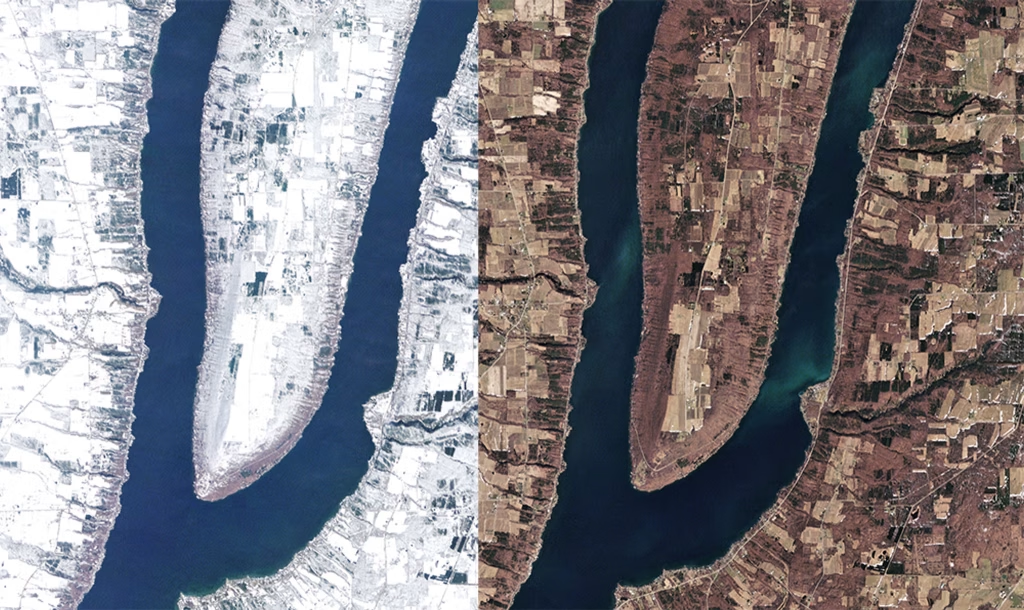
RapidEye image of Lake Keuka, New York © Credit: Planet Labs Inc.
A single satellite image records the condition of a place at one moment. Repeated observations can show a forest being cleared, a coastline shifting, a city expanding, floodwater moving across a landscape, or crops changing throughout a growing season. The map is no longer limited to showing where something is. It can also preserve a sequence of what happened there.
Researchers, governments, companies, and communities can compare images across time to trace patterns that may be difficult to recognize from the ground or impossible for one person to observe directly. An event does not always have to be anticipated in advance because earlier images may already exist in the archive, allowing someone to look backward as well as forward.
The comparison with the Marshallese examples is conceptual rather than technological. A mattang represents relationships in how an environment behaves rather than simply where land is located. Repeated satellite imagery can also move beyond location by showing movement, change, and relationships across time. One comes from generations of close observation and navigational knowledge; the other depends on spacecraft, sensors, software, and a constantly growing digital archive.
Satellite observation also complicates the idea that technological mediation always separates us from an environment. Most people will never personally witness deforestation across an entire region, follow the full extent of a flood from the ground, or watch a coastline change over years. Satellites can make those processes visible. At the same time, what eventually reaches us has passed through sensors, orbital systems, processing software, and often automated analysis before it appears as an image or dataset we can interpret.
Satellite systems extend human perception far beyond what any individual could see or remember, while making our understanding more dependent on the systems that collect and organize that information.
What Happens When Knowledge Moves Outside of Us?
As more observation, memory, calculation, and interpretation move into external systems, the question is no longer only what those systems can do, but what people no longer have to carry themselves. GPS can maintain a route, satellites can monitor environments at scales no person could observe directly, and software or AI can sort through patterns that would be difficult to identify manually.
That shift changes which skills and forms of knowledge remain active in everyday use. A person can follow a route without learning the surrounding street network, or interpret satellite imagery without ever visiting the place being observed. Wayfinding traditions make the contrast visible because observation, memory, and movement were often tightly connected: stars, swells, winds, timing, direction, and environmental change had to be recognized and remembered as part of the act of navigation.
When a system of knowledge is no longer practiced, the loss can extend beyond the technique itself. Navigation can carry language, stories, environmental knowledge, teaching traditions, and relationships between people and place. These are also forms of cultural heritage. Preserving an artifact or recording a method does not necessarily preserve the living knowledge required to understand, practice, and pass it on.
Traditional navigational knowledge in parts of the Pacific became vulnerable as transportation, education, and social conditions changed. The revival of non-instrument voyaging required navigators such as Mau Piailug and Nainoa Thompson to preserve, teach, adapt, and rebuild knowledge that was no longer being transmitted as widely. What could be lost was not only a method for reaching an island, but a larger system for reading and understanding the environment.
Technology can preserve knowledge, extend it, and make entirely new kinds of observation possible. It can also make some forms of knowledge unnecessary enough that people stop carrying them themselves. The technical question of what a system can do therefore sits beside a cultural one: what knowledge remains active, what becomes archived, and what may disappear when a tool takes over part of the relationship between people and their environment.
Space Through a Technological Lens
Space brings the question of mediated knowledge into its clearest technical form. Once we move beyond what can be observed directly from Earth, nearly everything we know about an environment depends on instruments, spacecraft, models, software, and data.

High-resolution topographic map of the Moon created from Lunar Reconnaissance Orbiter data. Credit: NASA/Goddard Space Flight Center
Most human understanding of the Moon, for example, comes through images, spectra, elevation models, rover measurements, orbital observations, maps, simulations, and interpretations of those datasets. Cislunar space is understood through coordinate systems, orbital mechanics, communications geometry, trajectory models, and measurements that human senses cannot interpret unaided.
Those systems do more than extend human vision. Spacecraft can map planetary surfaces, identify chemical compositions, monitor radiation, and estimate their own position using stars, terrain, asteroids, or planetary horizons. Some of the environments we are beginning to navigate are therefore experienced first as data and relationships rather than as places a person can directly see or physically enter.
What becomes visible depends partly on how those systems are designed. Mission designers choose which instruments fly and where measurements are taken. Sensors determine which phenomena can be detected, software determines how observations are processed and combined, and interfaces determine which layers a researcher or operator sees. Algorithms may identify patterns before a person ever examines the underlying observations.
That dependence on technological systems does not make the knowledge less real, but it does make the assumptions built into those systems worth examining. Tupaia’s Map offers a useful parallel: European readers had geographical information directly in front of them and still struggled to understand what it communicated because they expected the representation to follow familiar conventions. Better instruments and larger datasets do not remove the possibility of interpreting accurate information through an incomplete framework.
Building Better Lenses
The history traced through these examples does not reduce to a choice between Indigenous knowledge and modern technology, or between memorization and automation. Different systems make different relationships visible, and as maps beyond Earth become operational tools, those choices become practical.
A lunar map may combine topography, illumination, temperature, water ice, communication coverage, radiation, infrastructure, landing hazards, scientific sites, and heritage locations. Cislunar maps may need to represent position alongside velocity, time, gravitational relationships, spacecraft traffic, debris, communications links, and trajectories through an environment in constant motion.
The opportunity is not simply to collect more layers of data. It is to build systems that help people understand why those layers matter and how they relate to one another. A resource map can identify useful materials without making geology, science, or heritage invisible. A navigation system can calculate a trajectory while still helping an operator understand the orbital relationships producing it. Autonomous spacecraft can perform more sophisticated analysis while preserving enough context for humans to understand the environments those systems are interpreting.
Humanity has become very good at building tools that extend perception beyond the limits of our bodies and memory. That capability is essential to becoming a spacefaring society because most of the places we want to explore cannot be understood through direct human experience alone. The history of wayfinding adds something technology cannot decide for us: which relationships we consider meaningful, which knowledge we preserve, and which parts of an environment our tools train us to notice.
As we build more sophisticated maps of worlds beyond Earth, precision will only be part of the problem. We will also need to understand the lens through which that precision reaches us, what it reveals, and what it may allow us to stop noticing for ourselves.
Sources and Further Reading
International Dunhuang Programme / British Library
British Museum
University of Potsdam
The Journal of Pacific History
Polynesian Voyaging Society / Hōkūleʻa
Smithsonian Ocean
Navigating the Waters with Micronesian Stick Charts
The Oceanography Society
Archaeological Institute of America
NASA
Miniature Satellites with Massive Benefits
High Resolution Topographic Map of the Moon
Planet Labs
Scientific Reports
Habitual Use of GPS Negatively Impacts Spatial Memory During Self-Guided Navigation
Journal of Environmental Psychology